

Cox Peninsula and Bynoe Harbour
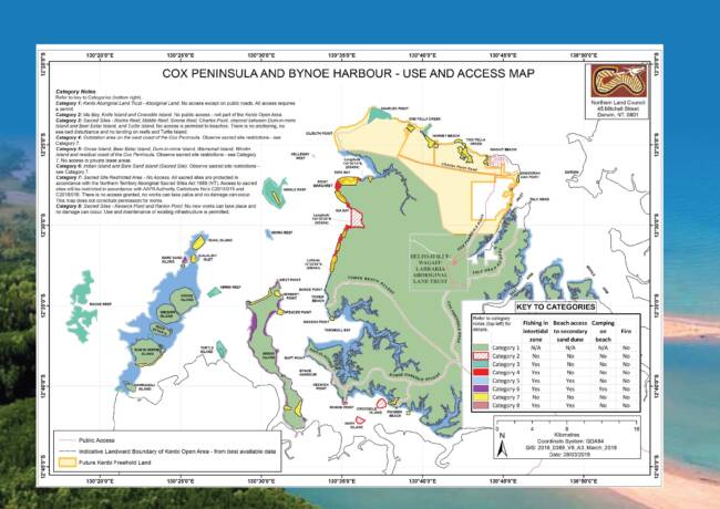
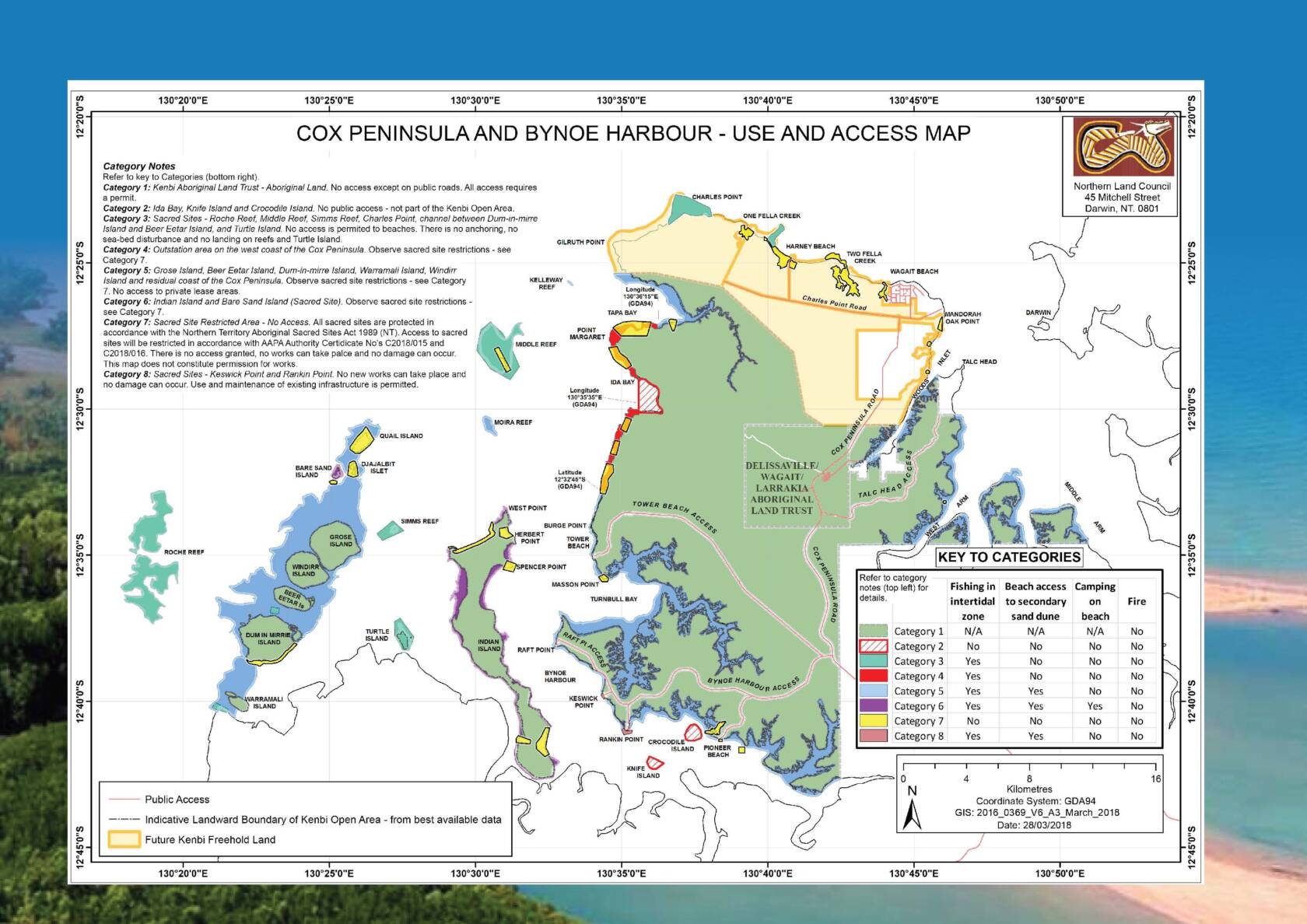
Access to some areas in the Cox Peninsula vicinity is regulated. The public can access specific beaches and fish in the designated intertidal waters and reef areas of Cox Peninsula and Bynoe Harbour without a permit. These are clearly marked on the Cox Peninsula and Bynoe Harbour – Use and Access Map below.
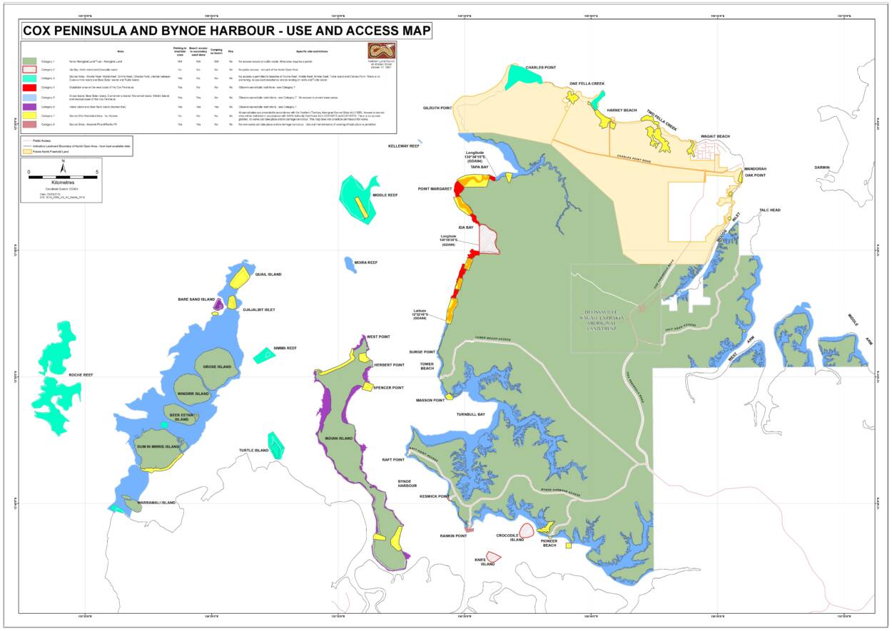
Cox Peninsula and Bynoe Harbour Use and Access Map
Cox Peninsula and Bynoe Harbour Use and Access Information Brochure
Section Map: Mandorah Access Map
Section Map: North Beach Access Map
Section Map: Charles Point Access Map
What areas can I access without a permit?
Beach access from the intertidal zone (where permitted) means that you can go ashore as far as the crest of the secondary sand dune, or if there is no secondary sand dune, you can go 50 metres beyond the inland boundary of the beach. The map also sets out the boundaries of the areas around sacred sites where access is prohibited. Penalties do apply. It is your responsibility to know the location of sacred sites.
You do not need a permit to use the following roads and tracks in this area:
- Cox Peninsula Road
- Wagait Tower Road
- Charles Point Road
- Harney’s Beach Track off Charles Point Road
- Talc Head Road to Mica Beach off Cox Peninsula Road
- Pioneer Beach track off Bynoe Harbour Access Road
- Rankin Point track off Bynoe Harbour Access Road
- Keswick Point track off Bynoe Harbour Access Road
- Tower Beach Road to Masson Point
- Raft Point track off Bynoe Harbour Access Road
All other roads and tracks on Aboriginal land require a permit.
What areas must I avoid?
Access is prohibited to:
- Quail Island, Djajalbit Islet and the northern beach of Indian Island; and
- Two Fella Creek and other areas in the northern Cox Peninsula.
These areas contain a number of sacred sites.
Background information
Since 2016, about 52,000 hectares of land on the Cox Peninsula, including a number of islands and reefs in Bynoe Harbour, have been classified as Aboriginal land under the Aboriginal Land Rights (Northern Territory) Act 1976 (Cth). This land is private land but some areas are open for access to the general public.
As part of the settlement of the Kenbi Land Claim, the Northern Land Council and the Northern Territory Government negotiated a compensation package to allow for people to access beaches and to fish in the intertidal waters and reef areas of Cox Peninsula and Bynoe Harbour without a permit.
However, permit-free access was restricted in some areas and prohibited in others. Sacred sites have always been protected in accordance with the Northern Territory Aboriginal Sacred Sites Act 1989 (NT) and access to sacred sites has always been restricted in accordance with that Act. In June 2016, the NLC published a map which detailed those restrictions.
Since then, the Government has worked closely with the NLC and the Aboriginal Areas Protection Authority to map in detail restrictions around sacred sites. The 2016 map has been refined following extensive consultations by AAPA and NLC with Traditional Owners and custodians.
The NLC welcomed the official gazettal on 22 March 2018 of the Kenbi Open Area Declaration over beaches and the intertidal zone of Aboriginal land in the Cox Peninsula vicinity. This Declaration gives certainty to the public as to where they will be able to travel and fish at Cox Peninsula.
Frequently Asked Questions
- 1. Which areas can I access?
-
Please refer to the maps above.
- 2. What is a sacred site?
-
Sacred sites are places within the landscape that have a special meaning or significance under Aboriginal tradition. Hills, rocks, waterholes, trees, plains, lakes, billabongs and other natural features can be sacred sites. In coastal and sea areas, sacred sites may include features which lie both below and above the water. Sacred sites derive their status from their association with particular aspects of Aboriginal social and cultural tradition. This body of tradition is mainly concerned with the activities of ancestral beings, collectively known as ‘Dreamings’ whose travels across the land and sea created the physical and social world that people now inhabit. Sacred sites within the Northern Territory are recognised and protected as an integral part of Australia’s cultural heritage, mainly under the Aboriginal Land Rights (Northern Territory) Act 1976 (Cth) and the Northern Territory Aboriginal Sacred Sites Act 1989 (NT).
- 3. Why can’t I access Quail and Djajalbit Islet?
-
Quail Island and Djajalbit Islet are important sacred sites that are subject to traditional restrictions on access and other traditional sanctions that are observed by Traditional Owners. Quail Island contains an important traditional burial area, and both islands are focal sacred sites associated with important dreaming ancestors. Traditional Owners and custodians ask people to respect these sacred sites by observing these restrictions.
- 4. Why can’t I access the northern beach of Indian Island?
-
This area is an important focal sacred site associated with one of the key dreaming ancestors in this area. Burials are also present in this area. Traditional Owners and custodians ask people to respect this sacred site and burial area by observing these restrictions.
- 5. Why can’t I access the coastal creeks along the northern Cox Peninsula?
-
Access to coastal creeks are restricted to protect a number of important sacred sites that are subject to traditional sanctions and gender restrictions. Traditional Owners and custodians believe that any unauthorised activity or damage in these areas could have serious repercussions for them under their traditional law. Traditional Owners and custodians ask people to respect these sacred sites for their safety and also the safety of visitors to this area by observing these restrictions.
- 6. What do the changes mean for the community of Wagait Beach?
-
There has been, and will be, no change to the tenure of Wagait Beach. Wagait Beach is freehold land and remains outside of the future Kenbi Freehold Land.
Related Resource
Sacred sites protected under final Kenbi Open Area Declaration
Mar 22, 2018
The Northern Land Council has welcomed the official gazettal this week of the Kenbi Open Area Declaration over beaches and the intertidal zone of Aboriginal land in the Cox Peninsula vicinity.
The two AAPA Authority Certificates are held by the Northern Territory Government and are available by clicking the links below: